 Restoration of Lake Hornborga-2017
[ Innehåll
]
|
|
|
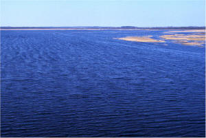
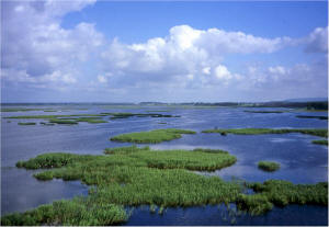
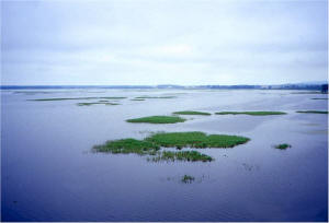
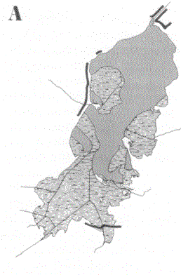
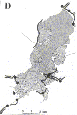
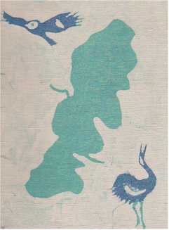
Lake HornborgaBackgroundAmong the numerous lakes degraded through water level lowering in Sweden, Lake Hornborga (in Swedish, Hornborgasjön, location 58°29'N, 13°34'E, Figure 1) in the province of Västergötland, is the best known. This is partly because the lowering was a legal scandal and a big economic failure, and partly because extensive basic investigations have been made there, concerning the possibilities to restore this type of shallow, drained lakes. The eco-technical restoration methods elaborated at Lake Hornborga were applied there already in the 1960s (Björk 1972).
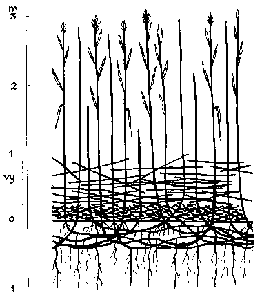
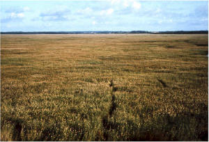
Figure 1. Lake HornborgaCauses of degradationUntil man interfered with the well-organized complex of components that functioned within the Lake Hornborga ecosystem, it maintained a rather high degree of productivity without suffering from rapid ageing. This is quite remarkable for a lake of this size (30 km2), shallowness and high trophic level. The lake used to have a maximum depth of 3 metres, but most of the lake was much shallower. A constellation of factors such as rapid water renewal, well-situated inlets and outlets (Figure 1), strong water and strong ice movements, provided a good system for transporting matter out of the lake and prevented it from becoming overgrown. The emergent vegetation was mainly restricted to wind-protected shore areas. The organic matter of the richly developed submerged vegetation easily decayed and was transported out of the lake, while the precipitated calcium carbonate particles covering these plants settled to the bottom. Before degradation following the water level lowering and finally, in 1933, complete drainage, Lake Hornborga ranked as one of the most valuable lakes for waterfowl in northwestern Europe. Since 1802, the lake has been lowered five times in attempts to obtain arable land. The last big failure, in 1932-33, resulted in a bottom drained in the summer, and which, in a considerable part of the lake, consisted of lake marl. A hilly land area of about 616 km2 drains into the lake. This area needs the Lake Hornborga as a reservoir to catch rainwater and melted snow that rush down the hills to the plain below. In 1954, the water level was slightly raised in the northern part (12 km2) of the lake that was diked-in (Figure 1). This could be looked upon as a large-scale field experiment. As described below, it revealed, amongst other things, the necessity of removing the macrophytic vegetation and of restoring a clean sediment bottom in areas intended to be re-created and preserved as open water with submerged vegetation. During the 1930s until the middle of the 1960s, the Hornborga area went through the typical development for lowered, shallow lakes and their drained surroundings. The lake area became overgrown by emergent vegetation. In fact, the slight raising of the water level in 1954, to a maximum depth of c. 80 cm in the diked-in portion, considerably improved the environmental conditions for common reed which had colonized the lake bottom. Huge masses of coarse detritus accumulated and filled in the lake basin (Figures 2 and 3). At the same time, the surrounding organic soil areas subsided. Altogether this resulted in fairly severe flooding and it became impossible to cultivate the successively wetter organic soils.
Figure 2
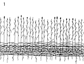
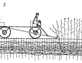
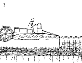
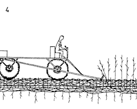
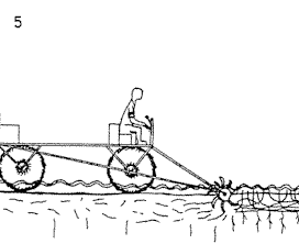
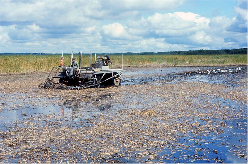
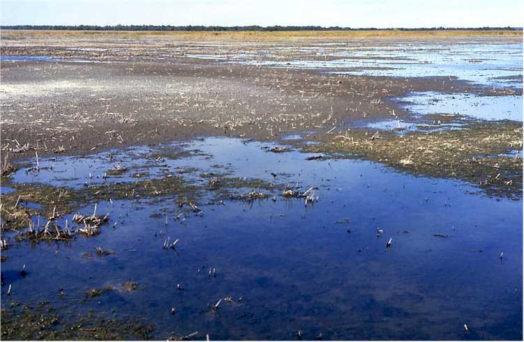
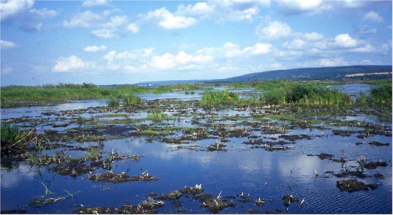
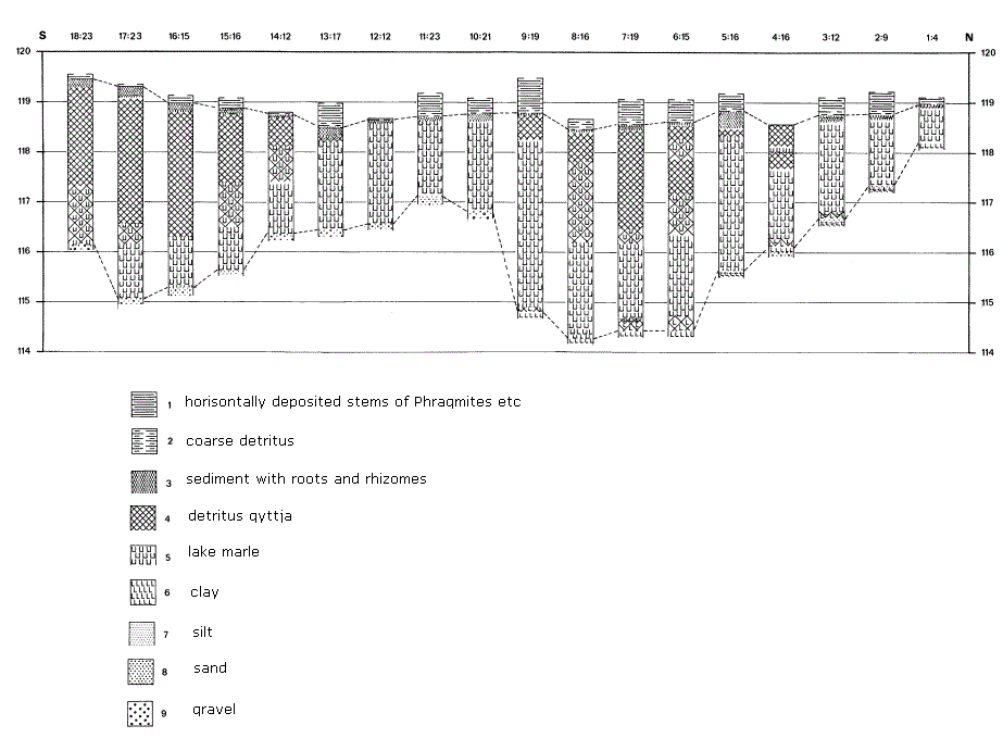
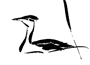
Figure 3. The Lake Hornborga restoration project.Lake Hornborga lost its value as an outstanding waterfowl habitat because the lake ecosystem's structure and function were completely destroyed. Monocultures of common reed (Phragmites australis, Figure 8, upper left photo) and slender-tufted sedge (Carex acuta), nearly covered the whole lake area in 1967. Mixed plant communities including living and dead willow bushes (Salix spp.) made large areas almost impenetrable. Basic research, arguments and directives for restorationThe legal course of events, including the long series of illegal ingredients, leading to the destruction of the great natural asset of Lake Hornborga, was revealed by Swanberg (1959a, 1959b, 1968, 1971). He elucidated the very serious economic and ecological consequences of the drainage project. Thanks to Swanberg's basic research and persevering, convincing argumentation, it was successively realized by all parties concerned that the drainage project was a multidimensional failure that had severely hit both nature and culture. The Swedish Government finally decided to investigate the possibilities to restore Lake Hornborga. According to governmental directives, investigations to determine whether or not the lake could still be restored and whether restoration would be sufficiently permanent were to be carried out (Vilborg 1973). In the case that restoration would be theoretically possible, methods to attain this goal were to be elaborated. Restoration goalsThe ecological goal for most restoration projects in lowered and overgrown lakes is to create an open water area and a mosaic of open water and emergent/ submerged vegetation. The restored lake/wetland should be brought to a stage of permanence where no future extensive management programme is needed. For responsible, long-term planning of wetland restoration, management and protection, this is of the utmost importance. Shallow lake ecosystems are not at all static but highly dynamic systems and can suffer from very rapid ageing processes. After water level lowering, as well as after an insufficient increase in water levels as a means of ‘restoration’, such lakes usually pass through a transient period of flourishing birdlife. Sometimes, as in the Lake Hornborga case, it is still difficult to convince the general public that this period is of just short duration and that ecologically realistic measures to counteract the rapid ageing must be taken in order to give the ecosystem sustainable character. When planning for restoration of such systems to sustainable units – according to man's time-scale - it is necessary to apply an holistic approach not only in space, i.e. to comprise the whole ecosystem including its catchment area, but also in time, i.e. to allow for the factors which have an influence on the speed of the ageing processes. Field investigationsThe field investigations started in 1967 and were carried out by a team of ornithologists (under the leadership of Dr. P.O. Swanberg), limnologists, technologists, hydrologists, economists and agriculturalists. In 1968, the lake and its subsiding surrounding areas were mapped using aerial photographs to obtain contour maps with a 25 m interval. Following the governmental directives, the necessary limnological restorative measures and developmental prognoses were elaborated, based on the specific conditions in the degraded Lake Hornborga itself. As the ecological properties in every lake/wetland ecosystem are unique, a tailor-made restoration plan has to be designed for each individual project. One year of limnological studies made it quite clear - theoretically - that Lake Hornborga could be restored (Björk 1972). The most serious problem following the lowering of water levels in shallow lakes is the development of a root-felt in the upper sediment layer and the accumulation of coarse plant material (detritus) produced by highly productive macrophytic vegetation. With clear evidence, the results of the limnological investigations demonstrated that before the decisive step for the restoration of Lake Hornborga - i.e. the raising of the water level - was to be taken, the bottom had to be treated in order to get rid of the coarse plant material and the root-felt. In 1968, large-scale field experiments were begun in order to develop the technical methods necessary to counteract the otherwise irreversible damage, i.e. the huge masses of accumulated detritus as well as the root-felt of the emergent macrophytes had to be removed (Figures 3, 4 and 5). If the water level is to be raised over areas overgrown by sedge (Carex), reed (Phragmites), bulrush (Schoenoplectus) etc., the gas (mainly methane) produced in the bottom accumulates in and beneath the root-felt. After a period of time the root-felt would, therefore, float to the surface and would soon be overgrown by new vegetation. This process leads to plaur formation (floating stands of emergent macrophytes). Project designThe basic limnological investigations carried out in all parts of Lake Hornborga included both the inflowing streams and the outflow, and the well-documented changes in the ecosystem following the drainage. Bottom levels, sediment, peat, water and flora were studied and the results were synthesized with findings from the groups responsible for ornithology, hydrology, etc. The ecological restoration plan for Lake Hornborga was presented in 1973 (Plan/73, cf. Björk 1972, Swanberg 1972, 1973, Vilborg 1973). In Lake Hornborga, as elsewhere, the sedge root-felt poses a problem, as it is thick, resistant and for economic reasons impossible to remove from the very large areas covered by it (c. 18 km2). In small water bodies, the floating root-felt can be removed by means of a dragline, or cut up, towed to the shore and removed. The reed root-felt can easily be cut by amphibious rotavators that were constructed for the Lake Hornborga project (Figure 4).
Figure 4. Lake Hornborga. Prototype of rotovator for removal of the stubble mat and rhizome layer of Phragmites. The slowly moving knives cut the rhizomes in long, easily-floating pieces.Following the governmental directives, the limnological project goal for Lake Hornborga was to transform the reed (Phragmites) areas to open water (about 11 km2) and to keep emergent vegetation in the area covered by sedge (Carex) (about 18 km2). When the water level is raised, the sedge root-felt will float to the water surface and be recolonised by reed (Phragmites) and bulrush (Schoenoplectus). Before raising the water level, the tough sedge root-felt can be removed from small areas by means of amphibious excavators. After raising the water level these parts will be preserved as open waters surrounded by plaur vegetation and attractive for birds.
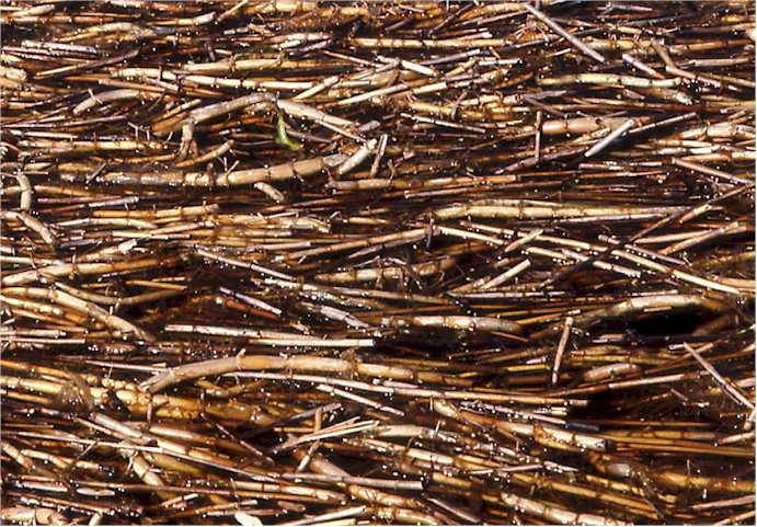
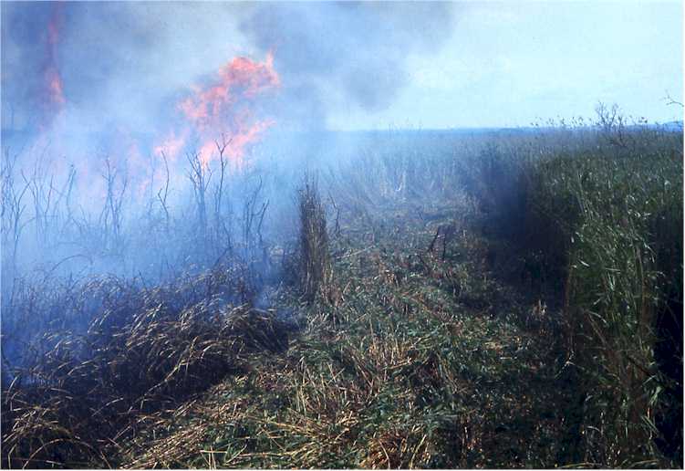
Figure 5. Lake Hornborga. Accumulation at the shore of Phragmites rhizome pieces after cutting with rotovators. Björk 1969.The procedure to replace emergent plant cover by submerged vegetation is illustrated in Figure 3. During the field experiment in the years 1968-1972, convincing results for a successful restoration using the above series of methods were obtained. For cutting macrophytic vegetation and destroying the root-felt, prototypes of amphibious and pontoon machines were developed. The use of the constructed equipment is schematically shown in Figure 3, according to dry and flooded conditions characteristic for the drained Lake Hornborga in the 1960s and 1970s. During dry periods in late summer and early autumn it was sometimes possible to quickly clean several km2 from accumulated reed detritus by means of fire (Figure 6), especially in the sections of the lake where willow bushes prevented the immediate use of machines. However, the fire does not destroy the root systems. Therefore, the productivity of the reed becomes higher since the fire has improved the environmental conditions through removal of the layers of settled detritus and dry stems which decrease both temperature and light at the bottom.
Figure 6. Lake Hornborga. Burning reed in late summer. Björk 1971.It is usually most practical to start the removal of the macrophytic
vegetation along the wind-and wave-exposed shores. During periods of high water
level, the cut and loosened plant material is transported to the exposed shore.
During low water periods it is possible to burn it on the shore or to collect
and compost it. In small-scale projects, it is practical to carry out the
cutting and root destruction in sub-areas surrounded by floating booms. All the
loosened material is dragged within the boom to the shore and removed from the
lake by means of a conveyer belt. With the procedure as described in Figure 3,
enormous masses of coarse detritus deposited in the stubble mat was loosened and
together with the rhizomes and roots transported by the spring high water to the
shores along the wind-exposed portions of the lake where they were burned in the
summer.
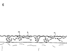
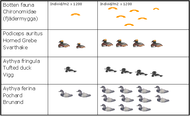
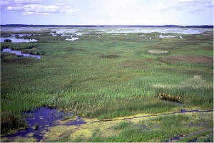
Figure 7. Lake Hornborga before and after the demonstration experiments for directing the production from emergent to submerged vegetation. Water level not yet raised . Comparison between conditions in 1965. (Data from H Berggren and PO Swanberg. From Björk 72)The restoration of bottom areas primarily overgrown by common reed (Phragmites) is an easy procedure by means of the technical equipment developed for the Lake Hornborga project. Even if the root-felt of bulrush (Schoenoplectus) and sedge (Carex) could be cut by rotavators, the main part of the loosened material would remain on the bottom, stationary or partly drifting. In case of common reed, the internodes of big pieces of stems and rhizomes are filled with gas, providing them with excellent buoyancy (Figure 4, 5). It is imperative that the rotavators cut the rhizomes in big pieces. Machines making slurry of both stems and rhizomes are destructive because the buoyancy of the material gets lost and the bottom is not cleaned but becomes covered by a layer of coarse, partly drifting particles. Methane gas develops in the degradation process of the organic matter prepared in that way. After treatment of 11 km2 of the bottom as described, and manual removal of trees and especially bushes along the shores and in the bays of the former lake, the restoration plan presented in 1973 (Plan/73) recommended the raising of the water level in two steps, first by c. 1 m and then, after about 5 to 10 years by a further 0.5 m. This procedure was recommended in order to get the wind-exposed shores worked up, cleaned and washed by the waves in a natural way. The primary raising of the water level should be sudden and big enough to prevent both successive recolonization of emergent species, mainly Phragmites, from the littoral zone and survival of initial stands in open shallow water areas. Before the lake degraded completely, Schoenoplectus was the characteristic species. After a restoration according to Plan/73, this species would again develop outside Phragmites stands along the shores and within plaur areas. With the distribution of the emergent vegetation under control by means of water depth, wave and especially ice action, the sediment bottom cleaned from coarse detritus could be largely covered by underwater vegetation (Figure 8 middle row left).
Figure 8. Lake Hornborga. Demonstration of restoration methods and recolonisation of treated areas. Sven Björk.
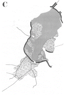
According to Plan/73 lowland areas adjacent to Lake Hornborga should not be cut off from the restored lake as shallow shores and vast wetlands also belonged to the most characteristic features of the former lake (Vilborg 1973). Plan/73 recommended the construction of 1) the compulsory dike at the outlet for making it possible to raise and regulate the water level and, in addition to that 2) short dikes for protection of still arable land against high-water floods, part of these landwards from large plaur areas (Figure 9).
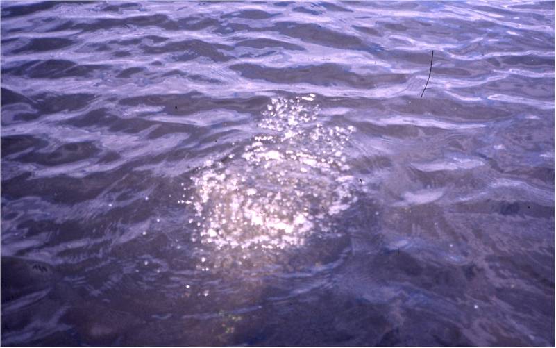
Figure 9. The extent of dikes according to plans and demandsProject ImplementationIn 1977, the limnological restoration plan of 1973 was unanimously accepted by the Riksdag (Parliament) and in 1982, the Water Court and the Government granted permission to raise the water level, in two steps, by 1.4 m. The Swedish Environmental Agency was responsible for the implementation of the plan. However, under their management, dikes, finally reaching a total length of 25 km, were projected around the lake and along tributaries. In addition to these, efforts were also made to get permission for construction of the Hertzman dike for reclamation of one of the lake's broad bays (Figure 9). The latter was, however, rejected by the Government. Because geological investigations had not been made at the suggested location of the dikes, the risks for leakage had not been assessed. Pleading the argument that depths greater than 0.4 m is a waste of water with regard to the environmental demands of many duck species, together with that of the leakage risks, the Environmental Agency changed the plan for the restoration of Lake Hornborga. The projected dikes (with the exception of the one at the outlet) were abolished and the water was to be raised by only c. 0.8 m, with the first water rise by 0.2 m in 1992. An overview of the treatment of Lake Hornborga after shrinking Plan/73 was in 1999 presented by Hertzman and Larsson. They argue that “the technical planning and the presentation of the restoration measures were formulated before the ecological implications of the suggested steps were fully analysed” and that “the prevailing idea” was “that if the limnological aspects were adequately addressed, the necessary ecological conditions for the birds would more or less automatically be created” (op.c. p. 68). Their plan, however, was not equipped with any environmental impact assessment (EIA). In accordance with the limnological prognoses given in Plan/73, plaur formation (root felt of Carex, etc., because of methane accumulation loosened from the bottom, and coming to the surface) soon started (Figure 10) after the rise in water level and ice movements occurred. The bird life has improved considerably. Incorrectly treated bottom areas are characterized by intense production of methane (Figure 11).
Figure 10. Plaur formation in the bay Västorpaviken, in the drained lake overgrown by Carex acuta. Björk 2000.
Figure 11. Ebullition of methane produed in a bottom treated with machines making a slurry of gyttja and living sedge. Björk 1998.Unforeseen has been the strong increase in the number of greylag geese (Anser anser) efficiently consuming reed-bed plants. The striking reduction of Phragmites has forced more than 75 % of the marsh harriers (Circus aeruginosus) to breed in Salix bushes instead of in reed-beds. In 2001 a total of 36 breeding pairs were recorded at the lake (Pettersson 2002). The future development of the ecosystem will serve as an illustrative example of the importance in restorative planning of a holistic view in both space and time. The further the ageing processes (filling in with sediment, peat and coarse detritus) have advanced in shallow lake basins, the more difficult it is to restore them by raising the water level. Ultimately, it becomes impossible. If the lake should be restored in a sustainable way, then that part not covered by revegetated plaur and bottom-rooted emergent plants must be large and deep enough to give the ecosystem the functional longevity as stressed in the original governmental directives for a restoration of Lake Hornborga, and not just give it a temporary appearance as an attractive waterfowl habitat. The open water should act as the 'heart and kidney' of the whole area, constituting an integrated part of the complex system, functionally powerful enough to preserve the vitality after restoration. Persistence of the results would, otherwise, be a matter of decades, not centuries. Every rise in the water level would, of course, cause a flourishing period for waterfowl, but the lower the rise the shorter the period. It must not be forgotten that even a limnologically correctly restored Lake Hornborga is severely damaged by the former water level lowering and that the restored system must be given a structural and functional capacity to withstand the increased nutrient loading. It should, amongst other things, have the capacity to metabolise nutrient-rich water from the agricultural catchment area (the 1954 diked-in lake was supplied with such water for only a short spring period) as well as anoxic water pressed out from the plaur sections during periods of decreasing water level. In this connection, chain reactions, including periodic oxygen deficiency and nutrient release, will appear and will affect animal survival and fertilisation of downstream waters. Within the open water area, the bottom should consist of sediment cleaned from root-felt and coarse detritus. Furthermore, the open water should be large enough to enable the formation of blue ice capable of pressing and pushing to keep exposed shores open as the ice did in the lake before its degradation. The evolution of shallow lakes/wetlands is, in several respects dependent on the conditions in the extreme years. Most important are the effects of dry periods with low water levels, especially if these effects in regulated lakes cannot be compensated by the effects of extreme high water periods. In dry years, the artificially shallow lake overgrown by emergent vegetation will suffer from extra water losses due to intensive transpiration from the plant cover. Within the dry littoral zone, plants will transpire groundwater which, otherwise, would have supplied the lake. In addition to this, agricultural irrigation may reduce the supply of water during dry seasons. The summarising effect of low water level in extreme years is a lakeward expansion of emergent macrophytic vegetation, resulting in increased production of accumulating coarse detritus. The Plan/73 for the restoration of Lake Hornborga also included measures to secure an even bottom in order to prevent sites from the accumulation of detritus and development of stands of emergent plants. Dikes along the drainage canals (Figure 1) had, therefore, to be levelled as part of the efforts to restore, as much as possible, the former wind-induced regime for in-lake water and ice movements. Methods to increase water depthWhen the water depth of a lake becomes too shallow, there are in general three possibilities to increase it: to raise the water level, to lower the bottom, or to combine these two measures. Under all circumstances the bottom has to be treated in order to get rid of the accumulated coarse plant material and the root-felt, a procedure which also results in a lowering of the bottom level. In Lake Hornborga, the removal of the root-felt and the dense stubble mat according to the Plan/73 would have lowered the bottom by c. 40 cm. Lake Hornborga is situated in an area where the bedrock, in some parts, consists of limestone. The characteristic sediment deposit in the northem section of the lake is lake marl, i.e. calcium carbonate precipitated as a result of the photosynthetic activity of a rich submersed vegetation. The marl is of high quality and excellent for the liming of acidified areas instead of spreading finely-ground limestone/chalk, obtained from quarries, and crushed and ground to fine fractions. In Sweden, where inland waters in oligotrophic areas are suffering from acidification, the liming of acidified lakes, brooks and catchment areas is state-financed (c. US$11 million per year in the middle of the 1980s). In lowered and completely drained lakes with lake marl as the characteristic sediment, modern automatic extraction methods have opened up possibilities for efficient sediment-mining aimed at the restoration of the lowered lakes, and the treatment of acidified land and waters. For Lake Hornborga, situated on the geological borderline between limestone and gneiss, lake marl is a characteristic sediment (Figure 12), and immediately southwest of the lake is the area of Sweden where the soils and waters are most severely affected by acidification. At the start of the Hornborga project, in the mid-1960s, acidification was not yet identified as an environmental problem and large-scale liming as a remedial measure was, of course, not introduced until later. |