Ornithological working methods in limnological research
P.0. Swanberg
In 1965 the Swedish government commissioned The National Swedish Environmental Board to make a plan for the future management of the drained and seriously damaged Hornborga Lake in central Sweden. The basis of this plan was to be related limnological ornithological and hydrological
investigations.
The ornithological investigation had four goals:
- to investigate the actual bird fauna,
- to study the ornithological results of experimental treatment of different test areas of the lake,
- to use the experience gained to assist in planning the future treatment of various parts of the lake and
4¤ to make a prognosis of the ornithological effects of the planned treatment.
The latter was the final aim, seeing that the Hornborga Lake once was the richest bird lake in Sweden. With this combination of a tailor - made plan for limnological treatment and an ornithological prognosis the importance of a restoration program could be well
demonstrated.
A thorough ornithological investigation of this lake involved a complex of problems, as the structure of the original lake ecosystem was destroyed by draining operations 1911 - 1965. The former lake area was almost completely covered by monocultures of reeds, Phragmites communis, sedge (Carex) and willows (Salix), which made it extremely difficult to study the waterfowl in the 25
km2 marsh.
The following working methods were drawn up:
 1 The macrophyte vegetation of the remaining 25
km2 marsh area was mapped on a scale 1:5000. This was made possible by a system of 18 East – West transect lines which were cleared by amphibious harvesters across the emergent vegetation to a width of 4 - 5 m
1 The macrophyte vegetation of the remaining 25
km2 marsh area was mapped on a scale 1:5000. This was made possible by a system of 18 East – West transect lines which were cleared by amphibious harvesters across the emergent vegetation to a width of 4 - 5 m
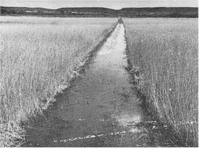
Fig 1 One of the eighteen transect (No 12) opened by an amphibious harvester from the eastern to the western shoreline. 15th June 1970.
These lines were made at 500 m intervals. It was then possible to make a satisfactory investigation from an amphibious vehicle and survey 250 m on both sides. The vegetation could be directly mapped as the location of different elements could be related to a system of poles dividing the lines into 100 m
sections.
2¤ A network of elevated observation points was built. With the large observation tower already constructed for visitors and a small, private tower at the northern end of the lake, there were six observation platforms in all, over a distance of 9.5 kilometres from south to north. An observation blind was built on poles at the edge of the only remaining open water.
This was done to study the relationship between different bird species and the dense submerged vegetation of Chara spp that rapidly
3¤ For 16 bird species the pairs/territories could be carefully mapped. Different methods were used. Four such methods were as follows:
 A The harriers, the hen harrier and the marsh harrier, Circus cyaneus & aeruginosus, were watched during nest building and in the period when the young were fed at the nest. It was necessary to divide the reed area into clearly defined sections that were watched for 2 - 3 hours in April - May and in June. We found it most important not to neglect any section, even if some of them seemed to be in different sections.
B The mute swan, Cygnus olor, was mapped from the air. The observer in the plane used a survey map showing the transect system and 100 m poles, and the air - plane followed the transect lines. As the nests of the swan were easily found and as it was possible to survey the area as far as the next line, it was sufficient to follow every second line. Each swan´s nest was immediately and carefully plotted on the map during the flight
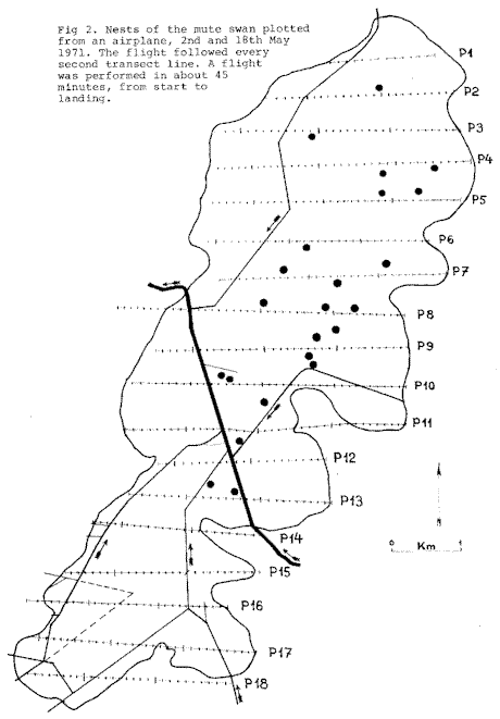
Fig 2.
C As for the grasshopper warbler, Locustella naevia, a satisfactory investigation was possible only during a few days from the day when all males were thought to have arrived. The reason for this was that the males of this extremely well concealed bird stop singing when nest construction begins a few days later. The investigation thus had to be made in a certain week. The marsh area was divided into sections which were investigated by different teams. The teams had to be on watch during appointed hours at dusk and before midnight, and this work had to be done in one or two successive days. The same method was also applied to the spotted crake, Porzana porzana, and to the corn crake, Crex crex.
D The numbers of some species that could not be censused by the line transect technique were mapped and estimated using observations collected during a long investigation period.
4. The crane, Grus grus, presented a complex of autecological factors to be studied. One of these factors which explains the concentration of cranes at the lake in April is the attractiveness of the marsh area as a roosting place. To study this, an 8 m high observation seat was made. From this the roosting habits in different years with different water levels could be
studied.
5. The black - headed gull, Larus ridibundus, presented special problems. As a consequence of the extensive reed cutting experiments, the gulls were spread in large, widely - dispersed communities. These colonies were censused in 1969 in the following way: The nests of a well defined community were counted on the 4th of June, in all 536 nests. On the following morning, 05.45 - 09.15, photographs of this and 6 other colonies were taken. The photographer took a suitable, more or less elevated position and directed with a walkie - talkie three groups that rapidly approached the colony from different quarters. The gulls were photographed in the very moment when all had been flushed from the colony. The gulls were counted in each colony photograph. The number of gulls in the photograph of the welldefined, checked colony above was 745. This was related to the true breeding number, 536 pairs. With this correction factor, 0.7195, we could estimate the total number of nests/pairs. Besides the colonies photographed and estimated in this way, nine smaller colonies were exactly counted. We thus arrived at a total of about 8100
pairs.
6. For checking the number of breeding ducks we used the following method: The entire area was investigated early in the season from the cleared transects. One day was spent north of the drainage dike Hornborgaån - Flian (inlet - outlet) and the next day south. Careful notes on the flight direction of the ducks and continuous communication with the other teams satisfactorily prevented double counting. This method was used for garganey, (Anas guerguedula), shoveler, (Anas clypeata), tufted duck, (Aythya fuligula), and for pochard, (Aythya.farina). For ducks migrating and breeding early in the season, the mallard and the teal, (Anas platyrhynchos & crecca), in which large breeding and migrating populations were mixed, no reliable working method was
found.
7. The line transect method. Besides those species that could be studied by the methods mentioned above, 38 breeding species remained to be investigated. This was made possible by the system of 18 open transect lines and 100 m poles. The transects were covered by canoe, boat, amphibious vehicle or by foot, according to the water level. Passerines were censused within a so - called supplementary belt, i.e. within 80 m on both sides. Coots, (Fulica atra), were counted within 100 m, redwing, (Turdus iliacus), water rail, (Rallus aguaticus), and snipe, (Gallinago gallinago), within 250 m, i.e. to the border of the next survey
belt.
The different species differed greatly in daily and yearly rhythms. We had to consider this and adjust the survey times to the habits of the different birds. It was not possible to make a census for all at once, and some had to be investigated at night. The total investigation distance amounted to 404 km.
8. Hornborga Lake has long been known as an important feeding and resting area for migrating birds, a reason for including Hornborga Lake in the international MAR - list, compiled by IUCN, ICBP and IWRB, now extended and called the CW - list. To study this and ecological significance of different biotopes for different bird species, the area was studied from the previously mentioned elevated observation points. This was done by different teams, sometimes repeatedly during those times of day that were suitable for each respective species.
Thanks to a devoted teamwork by 47 volunteers, mainly organized among the members of the Skövde Bird Club, it was possible to finish this investigation in 3 years, 1969 - 71. Owing to the fortunate possibility of working parallel with the general limnological investigation conducted by Sven Björk, it was possible to directly relate the rapid population changes found to the improvements achieved through the limnological experiments.
Figur 3. The rapid and positive effect of the experimental treatments in 1969 and 1970.
Comparision between 1968 and from Björk 1972a.
This gave us a reliable background to propose a tailor made treatment of the different habitats. It gave us, furthermore the basis necessary for estimating the effects of the restoration project designed primarily by Sven Björk and prospect by the National Swedish Environmental Protection Board. This project is awaiting approval by the Swedish Riksdag.
 Fågelutredningen-2017